A mysterious Chinese ‘research’ ship hovered for a suspiciously long time above Palau’s underwater data cable, a cable that will link Palau’s new long-range radar to the U.S.’s strategically important island of Guam
The country of Palau consists of 340 small and extremely small islands that are spread out over a large area. The archipelago is home to less than 20,000 people and its combined landmass covers only 490 square kilometers, but because of its scattered geography, its combined coastline is 1,519 kilometers and its Exclusive Economic Zone — where the nation has the exclusive right to fish and mine the ocean — spans a massive 616,000 square kilometers.
Just like in World War II, Palau’s location between Guam and the Philippines now once again makes it a strategically valuable collection of islands — as China builds its war machine and increases its aggressive rhetoric against Taiwan and the U.S. From the southern Philippines island of Mindanao one only has to travel 890 kilometers due east to get to Palau’s main island. From there, the large U.S. military bases on the island of Guam lie just 1,330 kilometers to the northeast.
The Palau archipelago’s Peleliu and Angaur islands were the scenes of bloody battles during World War II, when U.S. Marines had to dislodge Japanese defenders to get control of the important airstrips on these two islands. Because of these historic battles, the nearby ocean floor is dotted with the wrecks of fighter planes, landing craft and warships. The islands are known for their natural beauty as well as the hidden beauty of the large coral reefs that stretch around them. The rusting submerged war wrecks add to the allure of the coral reefs, making it a world-famous diving destination.
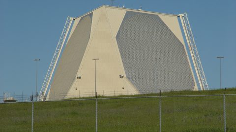
After World War II, the U.S. administered Palau until it gained independence in 1994. Since then it has ceded defense and security to the U.S. in exchange for economic assistance and other benefits under so-called “compacts of free association.” The archipelago’s officials have previously encouraged the U.S. to build military bases in the country as a way of boosting its small economy. The U.S. did little to take advantage of this offer until late December 2022, when it awarded a $118 million contract for the construction of reinforced foundations in Palau for “Tactical Mobile Over-the-Horizon Radar” equipment, which provides a much greater surface-sensing range than regular radar.
Brian Harding, an Asia expert at the U.S. Institute of Peace, told reporters in January that “this new facility will likely have a very light U.S. military footprint, but it’s clear that the Pentagon sees significant value in using Palau’s unique geography to employ this particular radar system.” The Pentagon’s Naval Facilities Engineering Systems Command Pacific is in charge of the project, and plans to have the new radar installed by June 2026.
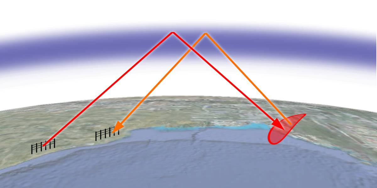
Technical documents show plans for two building sites — one for a receiver array and the other for a transmitter array — to be built at opposite ends of Palau’s main island cluster. The Pentagon did not divulge which type of over the horizon radar (OTHR) will be installed on the planned foundations. OTHR comes in two types. One version uses “backscatter” to detect airborne and surface objects as far away as 3,500 kilometers, but this version cannot detect anything closer than 100 kilometers. Another version uses “surface waves” to detect surface-skimming objects over a range of zero to 500 kilometers.
Both these OTHR types use relatively low-frequency waves (3 to 50 MHz) and can scan the Earth’s surface far beyond the horizon by “bending” their beams over the horizon. They differ from normal radar systems, which send and receive radar waves in straight lines and can therefore not see anything obscured behind their respective horizons. At a height of two meters above sea level, the ocean horizon is only 5 kilometers away, and at a height of eight meters, the ocean horizon is only 10 kilometers away — which illustrates how limited normal radar is in detecting surface objects over large distances. Even if you could place a normal radar on a mountain at a height of 500 meters, the horizon would be only 80 kilometers away — and there are very few small Pacific islands that have high hills, let alone mountains with unobstructed ocean views.
Backscatter OTHR can scan the Earth’s surface over a range of 3,500 kilometers because it pulses radio waves upward and at an angle towards the ionosphere, which is the ionized layer at the top of the atmosphere. Under certain conditions, the ionosphere will then refract the radio waves down to a large area on the Earth’s surface — thousands of kilometers from the radar transmitter. When this energy bounces off objects, some of that energy is reflected back the same way it came. These faint deflected-energy signatures are detected by the receiving station and identified as objects of different sizes, and their movements can thus be tracked. Such “backscatter” OTHR radar waves need to hit the ionosphere at an angle, or else the radio waves will go straight through the ionosphere without bouncing back. This is why this type of OTHR cannot detect objects closer than 100 kilometers.
Because of the long range of these scattered signals, the radar returns are extremely weak, and adverse atmospheric conditions can sometimes make these weak signals even weaker. That’s why such backscatter OTHR systems require very sophisticated hardware and software to tune the transmitted waves and process the received data. That’s also why OTHR systems have traditionally been used for early warning, rather than for precise targeting of enemy systems.
The other type of OTHR uses lower-frequency signals (2 to 3 MHz and sometimes up to 20 MHz) that tend to bend or “diffract” around curves. These waves interact with the conductivity of the ocean surface to form a “surface wave” that bends over the horizon and follows the curvature of the Earth. Once a radar wave hits a ship, airplane or missile that is not sufficiently stealthy, some of the wave energy will “bounce back” and travel back as a “surface wave” to reach the transmitting radar’s receiving array.
Both the above-mentioned types of OTH radars require long lines of antennas. For instance, Canada’s surface wave OTHR, designated HF-SWR-50 , consists of a long line of vertical monopoles that stretch over 660 meters. The monopoles are placed 50 meters apart, which corresponds to half the length of the waves emitted by the radar’s 3 MHz transmitter. The array can scan a horizontal arc of 120 degrees up to a distance of 370 kilometers, and it can obtain positions accurate to within hundreds of meters. The manufacturer of this radar, Raytheon Canada, stated that a similar array could be used to track low-flying cruise missiles if it operated at a frequency of 15 to 20 MHz — and at 20 MHz the wavelength would actually shrink to only 15 meters, so the monopoles would have to be only 7.5 meters apart.
Even though it operates at only 3 MHz, Canada’s above-mentioned HF-SWR-503 is used as an oceanic surveillance system for monitoring illegal activities like drug trafficking, smuggling, piracy, illicit fishing and illegal immigration. It can also be used for tracking icebergs and the remote sensing of ocean surface currents and winds.
While OTH radars are not accurate enough to get target locks on enemy units in order to guide missiles, they do fill gaps in a military’s situational awareness in very large theaters of engagement, which is what the Western Pacific certainly is. In a theoretical conflict over the Taiwan issue, such gaps in situational awareness will form and disappear as early-warning and missile-guidance platforms like airplanes, drones and satellites are disabled and later replaced. OTH radars like the one being built on Palau would be able to give valuable backup data if such gaps do form, while also providing early-warning data to tell defenders what to expect.
Next we’ll look at the suspicious Chinese “research” ship and what it could have been doing last week when it lingered long over Palau’s underwater data cable, which will connect Palau’s new radar with the U.S.’s vital but vulnerable bases on Guam island.
Image: Charly Whisky, CC BY-SA 3.0


Leave a Reply